The progress on the project for implementation of the River Information System in the Bulgarian stretch of the river Danube will be presented in the city of Rousse. The information system is part of the Pan-European system for providing efficient and...
The progress on the project for implementation of the River Information System in the Bulgarian stretch of the river Danube will be presented in the city of Rousse. The information system is part of the Pan-European system for providing efficient and safe navigation on European inland waterways transport.
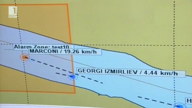
The River Information System will provide electronic access to data on the movement and positioning of ships on the Danube, pictures, notices and other messages related to the safety of navigation, environment and business.
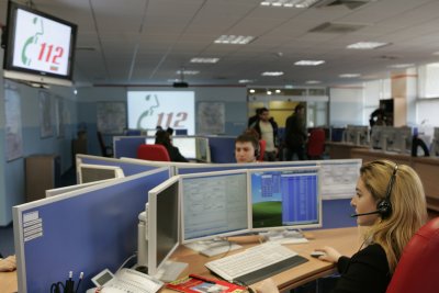
The whole vessel traffic and condition of the river will be monitored through radar systems and cameras. The system will ensure constant radio and internet connection to facilitate data exchange between vessels and shore services.
Seventeen communication points will perform the monitoring and controlling of vessels navigation along the Bulgarian stretch of the river Danube. The project ”Implementation of River Information System on the Bulgarian stretch of the Danube River” (BULRIS) is financed under the Operational Programme “Transport” and the overall budget for the whole project is 37 427 697 BGN.
The first phase of the project has already been completed. The telecommunication and radio stations and the main telecommunication infrastructure have been built. The software for visual traffic monitoring is available.
The River Information Centre, which will collect the whole information, is expected to be opened in April, on the river bank near the city of Rousse. The communication equipment is deployed on a stretch of nearly 650 km. The system enables an overall monitoring of the waterway, ensures enhanced safety and security control over the navigation and will minimize the risks from environmental pollution.
The system will also facilitate freight forwarders and logistics companies to trace their cargos in real time. It will be very helpful to ship captains as they will have the needed information to choose the safest and most appropriate route, to avoid running aground and to reduce the consumption of fuel.

 Ministry of Finance: We Are Taking Steps to Reduce the Deficit Starting With the 2027 Budget
 EU Finance Ministers Voted to Open an Excessive Deficit Procedure Concerning Bulgaria
 Премиерът: България защитава своя интерес, но не пречи на съюзниците си да защитават своя
 Доклад на ЕК за върховенството на закона: В ход е подобряване на независимостта на обществените медии


 Чуй новините
 Подкаст