Today, February 4, some areas are again recording sub-zero daytime temperatures, though this is now limited to western and central parts of the Danube Plain. There, dense fog will persist throughout the day, accompanied by drizzle and conditions favourable for ice formation.
Across the rest of the country, a moderate south to south-easterly wind will blow, with afternoon temperatures ranging between 2°C and 10°C, and around 3°C in Sofia. Skies will be mostly cloudy, with rain beginning in the coming hours, initially affecting south-western Bulgaria.
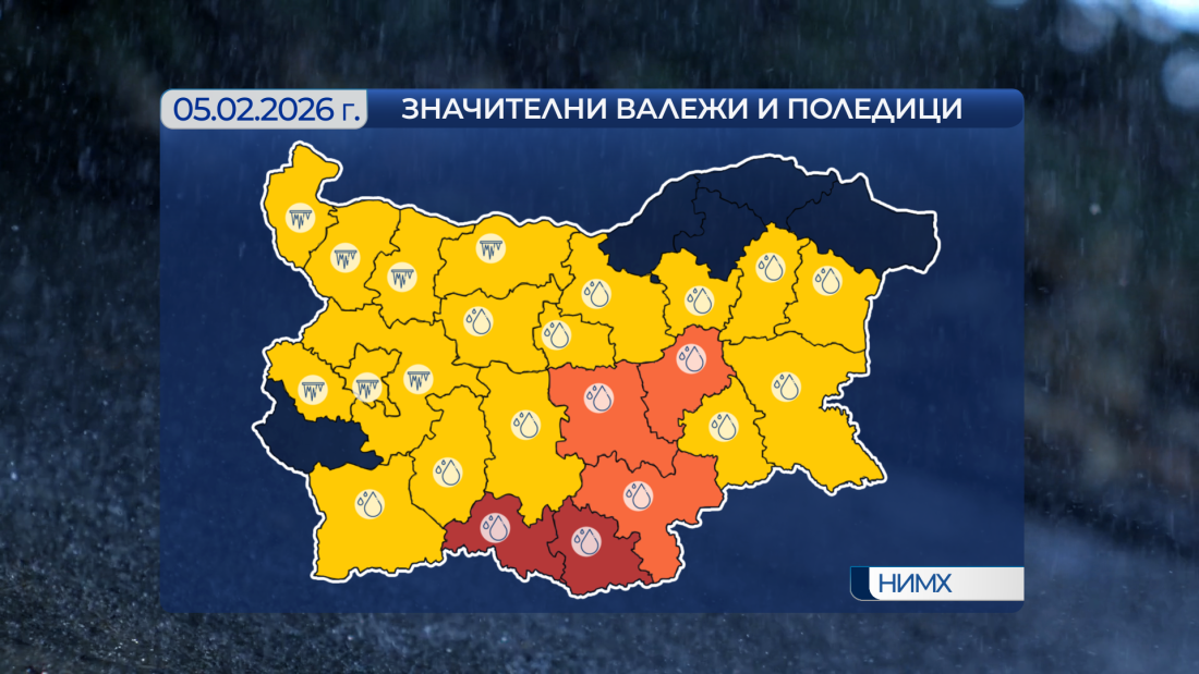
Rain will continue overnight, and tomorrow widespread rainfall — heavy in many areas — will cover almost the entire country. In regions under a red weather warning, local rainfall totals could reach or exceed 60 litres per square metre. Freezing conditions and ice are expected in western and central parts of northern Bulgaria.
Minimum temperatures in northern Bulgaria and the higher plains of western Bulgaria will range from –6°C to –1°C. In the southern half of the country and along the Black Sea coast, temperatures will be between 1°C and 6°C, with around –2°C in Sofia. Daytime highs in western and central northern Bulgaria will be between 0°C and 2°C. Elsewhere, where a moderate wind will blow — temporarily strong along the Black Sea coast — temperatures will range from 5°C to 11°C, reaching about 5°C in Sofia.
On Friday, rainfall will ease temporarily, but later in the afternoon rain will return from the south-west, with heavy precipitation quickly spreading across the country. Icy conditions will persist in north-western areas.
Saturday will be mostly cloudy but largely dry, with a continued rise in temperatures. Rain is expected to return on Sunday and Monday, and with a new and significant drop in temperatures, rain in many areas will turn to snow. A fresh snow cover is expected to form.


 Чуй новините
 Подкаст